3D in Maps
- Thread starter azonie
- Start date

You are using an out of date browser. It may not display this or other websites correctly.
You should upgrade or use an alternative browser.
You should upgrade or use an alternative browser.
3D in Maps
- Thread starter azonie
- Start date
azonie said:I see on commercials people using the 3 D feature Maps. It show detail of buildings in 3D. But I can never even see the buildings even in 2D.
How do you do this??
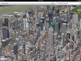
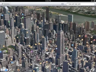
You have to be looking at a city that is supported by the 3D flyover feature and chose the satellite or hybrid view. When you're over a 3D area, do a two finger up swipe to tilt the map from a vertical to an angled view. Here's a 3D view of Manhattan.

 .
. Here's a view from the iPhone version of the maps.
Last edited:
azonie said:How do you when it is available.
If you're over a flyover supported city, you will see a building logo in the lower left corner, instead of 3D.
stevnim
Member
Assuming we're talking about Google Maps, both it and Google Earth share the same database, 3D tilting flyover included. There is a monthly "Google Earth Sightseer Newsletter" you can subscribe to, that shows the latest features of the program and database that is shared with Maps. That is also where new cities are covered with 3D flyovers are introduced.
stevnim said:Assuming we're talking about Google Maps, both it and Google Earth share the same database, 3D tilting flyover included. There is a monthly "Google Earth Sightseer Newsletter" you can subscribe to, that shows the latest features of the program and database that is shared with Maps. That is also where new cities are covered with 3D flyovers are introduced.
The 3D mapping feature in google earth is not nearly as good as the apple maps flyover feature. They do not use the same database, as there are different boundaries for the areas covered by the 3D feature in cities covered by both google and apple maps.
Last edited:
schollianmj
Member
- Joined
- May 1, 2012
- Messages
- 107
- Reaction score
- 9
The 3D mapping feature in google earth is not nearly as good as the apple maps flyover feature. They do not use the same database, as there are different boundaries for the areas covered by the 3D feature in cities covered by both google and apple maps.
Yea, but to bad the apple maps doesn't work properly... When I try to use it it lags behind where I actually am by a good distance. I Have missed turns in towns a few times because of this. I now and using Telenav Scout. It works, but I would much rather NOT have to add software to do the same thing that built in software should be able to do.
schollianmj said:Yea, but to bad the apple maps doesn't work properly... When I try to use it it lags behind where I actually am by a good distance. I Have missed turns in towns a few times because of this. I now and using Telenav Scout. It works, but I would much rather NOT have to add software to do the same thing that built in software should be able to do.
Do you have a WiFi only iPad? The position derived from triangulating on WiFi hotspots is not nearly as accurate as a GPS fix. That might explain your problems.
schollianmj
Member
- Joined
- May 1, 2012
- Messages
- 107
- Reaction score
- 9
Nope, iPhone 5....  it is normally about half to 3/4 a block behind me. I used it on the interstate the other day, and I watched an exit as I passed it and according to the map I hadn't gotten to it yet.
Similar threads
0
2K


